Telematics has several applications, such as commercial vehicle tracking and insurance telematics. It is worth understanding the basics.
Telematics is a combination of telecommunications and informatics. The joining of these two sciences created the field of telematics.
In its broadest sense, telematics includes the Internet, as it combines telecommunications (mobile phone networks) with informatics (such as computer systems and vehicle-tracking applications).
The technology enables the sending, receiving, and storing of vehicle information via Telematics hardware (Telematics Control Units) that are hardwired into vehicles, plugged into the OBD II or CAN-BUS port, or battery-powered. A SIM card and onboard modem inside the TCU enable communication through a mobile network. This device then records and reports various data points to a remote software application.
Telematics records and reports on more than just GPS vehicle location. For our needs to analyse location and activity, GPS, X, Y, and Z (acceleration and deceleration, lateral movement, and up-and-down movement) with date and time stamps are the main interest.
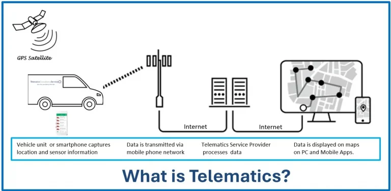
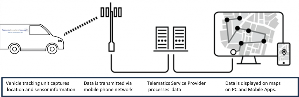
How does a telematics system work?
A vehicle tracking device, black box (Telematics Control Unit), or even a GPS-equipped smartphone is at the core of a telematics system. It collects GPS data and a wide range of vehicle-specific data. Data is transmitted via GPRS (General Packet Radio Service), 4G mobile data, or satellite communication to a centralised server. The server then interprets the data and displays it to end users.
The telematics device collects a wide range of data that, when processed, can provide in-depth vehicle information, such as location, speed, idling time, harsh acceleration or braking (X, Y, Z data measured by an internal accelerometer), and more.
All this data is then overlaid on a map in a telematics application in near real time and can be viewed via secure websites and apps optimised for smartphones and tablets.
The data the end user sees and uses to generate management reports is only a tiny portion of the service provider’s database.
This “raw” telematics data is required for a complete analysis. It contains data such as sequential record numbers, GPS latitude & longitude, XYZ values, quality values for the GPS satellite signal and date and time stamps—all critical data for a complete analysis.